We've profiled coffee, cocoa and rubber so far. Wood breaks the pattern the other three shared — it isn't a tropical crop the EU imports at scale. It's mostly a domestic industry with a smaller, high-scrutiny import segment layered on top.
The EU grows most of its own wood
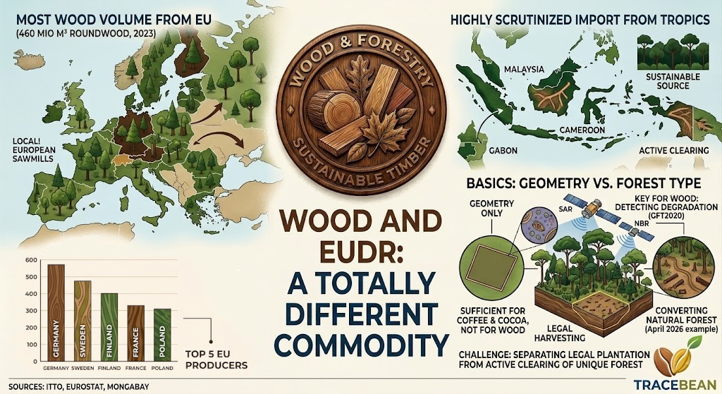
EU roundwood production reached 460 million m³ in 2023, led by Germany, Sweden, Finland, France and Poland — five countries producing 64% of the EU's total. Only around 16% of the EU's roundwood imports come from outside the bloc at all. That's a fundamentally different trade structure from coffee, cocoa or rubber, none of which the EU produces domestically in any meaningful volume.
The EUDR-relevant risk sits almost entirely in a narrower category: tropical hardwood and tropical wood products, imported under the EU's existing FLEGT framework (Forest Law Enforcement, Governance and Trade, in place since 2003) from Voluntary Partnership Agreement countries — Cameroon, the Central African Republic, Ghana, Indonesia, Liberia and the Republic of Congo — plus non-VPA tropical suppliers including Brazil, Malaysia, Gabon and Peru.
Where the tropical share actually comes from
Indonesia is the only VPA partner to have achieved full FLEGT licensing — a legality-verification system (SVLK) the EU formally recognised in 2016, meaning Indonesian shipments carrying a FLEGT licence are presumed legally sourced under existing EU timber law. Whether "legally sourced" and "deforestation-free" are the same claim is exactly where EUDR adds a new, separate layer on top of a framework that already existed.
A live example of why that distinction matters
An investigation into Indonesian plywood supply chains found that one Indonesian producer sourced 87% of its natural forest logs in 2024 — around 17,850 m³ — from active forest clearance inside a single logging concession. A second Indonesian exporter, the second-largest supplier of Indonesian timber to the EU in 2025, sourced roughly 8% of its intake from the same concession, which had cleared an area of rainforest roughly the size of Central Park that year.
The largest EU-based recipient of Indonesian plywood in 2024 changed its sourcing policy and strengthened its traceability requirements after being identified in the investigation. The second exporter said it permanently stopped buying from the implicated supplier.
Two things worth noting about this case. First, both companies acted only after being named publicly — not through a compliance system catching the issue beforehand. Second, the wood in question wasn't necessarily geometrically mislabeled or missing coordinates; the concession itself was the documented source, legally licensed to operate. The problem wasn't bad geo-data. It was that legal, licensed operation and active deforestation were happening in the same place at the same time.
Why detecting this is a fundamentally harder problem
Complete deforestation — forest to bare land — is detectable with over 90% accuracy using freely available satellite data; this is the problem Hansen GFC and GFC2020 were built to solve, and they solve it well. Forest degradation — a forest that remains standing but is being selectively logged, thinned, or converted in stages — is a different and much less mature science. Researchers count more than 50 competing definitions of forest degradation, with no internationally settled way to measure it, and selective logging in particular sits at the edge of what even high-resolution methods can reliably flag.
Available approaches each address part of the gap, not all of it. Synthetic Aperture Radar (SAR) sees through the cloud cover that blocks optical satellites across much of the tropical timber belt — a real limitation for Indonesia and Central Africa specifically. Specific spectral indices, like the Normalized Burn Ratio, are tuned to detect logging scars and clearings that broader indices miss. High-resolution commercial imagery, such as Planet's near-daily, 3.7-metre constellation, catches rapid changes that 30m public data misses — at commercial cost, not free. None of these fully closes the degradation-detection gap on its own.
A licensed concession and an actively deforesting concession can be the same polygon at different points in the same year. That's not a geometry problem, and it's not fully solved by any single dataset available today — public or commercial.
Where this leaves the fit assessment
Wood doesn't follow the smallholder-fragmentation pattern that shaped our reads on coffee, cocoa and rubber. The relevant supply chain runs through logging concessions and processing companies, not millions of individual small plots — closer in structure to how large coffee estates operate than to smallholder cooperatives. Geo-data validation still matters here: a concession boundary still needs to be a structurally valid polygon, correctly attributed to the right supplier, before anyone can reason about what's happening inside it. But the harder, more valuable question for wood specifically is whether the forest inside that boundary is the kind that regrows on a plantation cycle or the kind that shouldn't have been touched at all — closer to the GFC2020/GFT2020 forest-type distinction we've written about than to a pure coordinate-accuracy problem.
For wood, geometry validation is table stakes, not the differentiator. The harder problem — telling a legally regrowing plantation from a concession actively converting natural forest — is closer to what forest-type classification layers like GFT2020 are built for than to anything a coordinate check alone resolves.
We're treating this as an open architecture question, not a settled one: the detection science for degradation specifically is still maturing industry-wide, and any commitment here should follow a real supplier sample, not precede it.
Trade figures are drawn from ITTO (International Tropical Timber Organization) market reports, the FLEGT Independent Market Monitor, and Eurostat forestry statistics. The 2026 sourcing case is drawn from Mongabay's April 2026 investigative report on EU timber trade and Indonesian logging concessions. Detection-method research is drawn from peer-reviewed remote-sensing literature on forest degradation monitoring, including Asner (2009) and subsequent reviews.
← Back to Blog