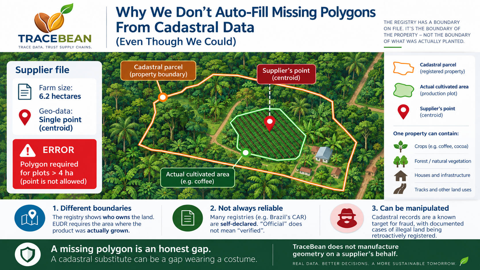
A file comes in. One of the farms is 6.2 hectares, according to the supplier's own declaration, but the geo-data attached to it is a single latitude/longitude pair — a centroid, not a boundary. Under EUDR, any plot larger than four hectares must be submitted as a polygon; a point is only acceptable at or below that threshold. This is a hard error. It cannot be guessed into compliance from the point alone.
In several of the countries our prospects source from, there is a public national land registry. Run a point-in-polygon query — does this coordinate fall inside a registered parcel? — and in some cases, yes, it does. The registry has a boundary on file. It would take one spatial join to attach it to the farm record and turn a hard error into a filled-in file.
We don't do this. Not because it's technically difficult — the query itself is trivial — but because every layer underneath it is weaker than it looks.
The temptation is real, and worth stating plainly
It would make our own numbers look better. A validation report with fewer unresolved errors looks like a better product. A prospect who sees "6 farms flagged, 0 auto-correctable" is a harder sell than one who sees "6 farms flagged, 6 auto-corrected." The incentive to reach for this is not hypothetical — it is built into how a validation tool gets judged.
That is exactly why it needs to be examined carefully instead of shipped quickly.
Reason one: a title boundary and a production plot are not the same shape
The registry answers "who owns this land." EUDR asks "where was this grown."
The European Commission's own FAQ document works through this exact scenario. A single estate property contains several sub-areas — call them Area A (the whole property), Area B (where soy is actually grown), and Area C (something else on the same estate). The Commission's answer is unambiguous: only Area B needs to be geolocated. The due diligence obligation attaches to the plot of actual production, not to the boundary of the property it sits inside. The FAQ goes further and states directly that polygons must not include area that does not belong to the production plot — over-inclusion is treated as its own kind of error, not a safe default.
A national cadastre, by design, records the first thing — the registered extent of a titled property — not the second. A 6-hectare title can easily contain 3 hectares of coffee, a stand of trees, a house, and a track. If we matched the supplier's centroid to the cadastral parcel and used that boundary, we would very likely hand back a polygon larger than the actual production plot — replacing a missing-data error with a compliance error that looks like a resolved file. That is a worse outcome than the flag we started with, because the flag was at least honest about what was missing.
Reason two: the registry is frequently a self-declared record, not a surveyed one
"Official" and "verified" are not the same word.
Brazil's rural environmental registry (CAR) is the clearest example available to us, because it is genuinely public and well documented: a free, national, parcel-level system covering millions of properties. It is also, by design, a self-declaration system — the landholder draws their own boundary. Nothing about pulling a shape from that registry makes it more trustworthy than the shape the supplier already sent us. It just moves the same uncertainty into a government-branded file, which makes it look more authoritative than it is.
If we quietly substituted a cadastral shape for a missing polygon, the validation report would present it with exactly the same confidence as a boundary the supplier walked and measured themselves. That is not a correction — it is laundering an assumption through an official-looking source.
Reason three: cadastral records are a documented target for exactly this kind of fraud
This is not a hypothetical edge case — it has a name in the literature.
A 2025 Transparency International / U4 analysis of corruption risk in EUDR implementation identifies manipulation of official land cadastre records as one of three primary mechanisms by which illegal land conversion gets laundered into supply chains. In Brazil's Amazon specifically, the same report documents cases where illegally occupied public forest was retroactively registered in the CAR system with the help of corrupt notaries — turning an illegal claim into an "officially registered" one after the fact. Separate research on Indonesia documents the same pattern with concession and cooperative records.
This is the part that goes beyond "the data might be sloppy." A cadastral boundary can be entirely internally consistent, properly formatted, and still describe a parcel that was fraudulently legalized. Cross-referencing a supplier's centroid against a registry like this doesn't just risk inheriting a boundary that's the wrong shape — it risks inheriting a boundary that was manufactured specifically to survive exactly this kind of check.
A missing polygon is an honest gap. A polygon quietly substituted from an unverified, occasionally fraudulent government record is a gap wearing a costume.
What we do instead
A centroid submitted for a plot the supplier has declared above 4 hectares is flagged as a hard, non-auto-fixable error — MISSING_POLYGON — the same category as a farm with no geo-data at all. It is reported to the importer as something that requires going back to the supplier, not something the file quietly moved past.
We are not opposed to national land registries as a future data source in principle. Where a registry is independently surveyed, kept current, and distinguishes registered extent from cultivated area, a cadastral match could reasonably become a candidate — a suggestion surfaced to the importer for human confirmation, never a silent substitution written into the record as if the supplier had provided it.
That is a meaningfully different feature from the one we are declining to build today, and it does not exist yet — not for any country, not on any roadmap. TraceBean does not manufacture geometry on a supplier's behalf. If the data isn't there, the report says so.
The broader pattern here is the same one that runs through everything else on this blog. A deforestation signal from Hansen data is a signal, not a verdict — a human has to decide what it means. A country's risk classification is a statistic about a population, not a fact about one farm. And a boundary pulled from a government registry is, at best, another data source with its own error rate — not a shortcut past the requirement to know where the commodity actually came from.
Sources: European Commission, Guidance Document for Regulation (EU) 2023/1115 (Notice C/2025/3588), FAQ 1.14–1.15 on plots of land within a single estate property; Etzo, S. A. (2025), "Land corruption risks in the implementation of the EU regulation on deforestation-free products," U4 Anti-Corruption Resource Centre / Transparency International, Helpdesk Answer 2025:33.
← Back to Blog