A question came up at World of Coffee that is worth sitting with longer than the conversation allowed: if an area of cleared land is smaller than half a hectare, does it actually count as deforestation under EUDR?
The short answer is yes — but the reasoning behind that "yes" reveals something about how the regulation defines a forest in the first place, and that definition has a consequence almost nobody asks about next: a meaningful share of the world's coffee farms are themselves smaller than the very threshold being discussed.
What the regulation actually defines as a forest
EUDR does not invent its own forest definition. It adopts, almost word for word, the definition used by the UN Food and Agriculture Organization — the same definition used in international forestry statistics for decades.
Three numbers, all of which have to be met simultaneously for an area to qualify as a forest: a minimum size of half a hectare, a minimum tree height of five metres at maturity, and a minimum canopy cover of ten percent. Land that falls short on any one of these criteria — including simply being too small — is not a forest under the regulation, regardless of how densely it might be wooded.
This is a deliberate design choice, not an EUDR-specific quirk. The FAO definition was built to be measurable consistently across very different landscapes and very different national forest inventories. A minimum area threshold gives the definition a clean edge — but every clean edge in a definition creates a category of things that fall just outside it.
So does clearing under 0.5 hectares count as deforestation?
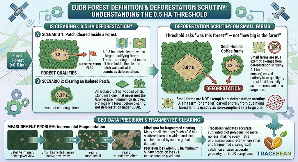
Here is where the reasoning matters more than the headline answer. If an area was forest before — meeting all three thresholds — and is cleared, that clearing is deforestation regardless of how small the cleared patch is. The 0.5-hectare threshold defines what counts as forest in the first place. It does not set a minimum size for an act of deforestation within an existing forest.
Clearing 0.3 hectares inside a 50-hectare forest block is still deforestation of that 0.3 hectares — the surrounding forest meets the size threshold, so the patch was legitimately forest before it was cleared. The question that actually has a different answer is narrower: what happens when an isolated, small wooded area — one that on its own does not span 0.5 hectares — is cleared in full?
A 0.3-hectare patch cleared from within a larger forest block that meets the 0.5 ha / 5 m / 10% thresholds. The surrounding forest qualifies; the cleared patch was part of it.
An isolated 0.3-hectare wooded patch, standing alone, that never met the 0.5-hectare minimum on its own. It was not legally a forest before clearing — so its removal is not deforestation under the EUDR definition.
The distinction is not about the size of what was cleared. It is about whether the land that was cleared was part of something that met the forest definition in the first place.
Now the question that follows
This is where the World of Coffee conversation pointed toward something genuinely important. A great many smallholder coffee and cocoa farms are themselves smaller than 0.5 hectares — and EUDR's own geolocation rules already acknowledge this, setting a separate, lower documentation threshold of 4 hectares for point-versus-polygon geometry, well above the forest definition's own 0.5-hectare floor.
Does this mean small farms are somehow exempt from deforestation scrutiny? No — and this is the distinction worth being precise about. The 0.5-hectare threshold applies to whether the land being converted was forest. It does not apply to the size of the farm being created. A one-hectare farm carved entirely out of a forest block that met the threshold is still built on deforested land — the farm's own small size does not change what the land was before it was cleared.
The threshold asks "was this forest?" — not "how big is the farm that replaced it?" A small farm built on previously qualifying forest land is exactly as non-compliant as a large one. The size of the resulting farm is irrelevant to that question.
Where the threshold creates a genuine measurement problem
The more interesting issue is not legal — it is technical, and it is the one forest-monitoring researchers have flagged directly. Applying a 0.5-hectare minimum mapping unit to satellite-derived forest data measurably reduces precision. Independent analysis published by the World Resources Institute found that forcing a 0.5-hectare minimum onto satellite imagery can make forest and deforestation measurements five to fifty times less precise than working from the satellite's native pixel resolution.
The practical effect is a blind spot for fragmented clearing — many small clearings, each below the threshold on its own, scattered across a wider landscape, none of which individually triggers a "this was forest, now it isn't" flag in a coarse-resolution dataset. The same pattern that makes the 0.5-hectare floor a clean legal definition makes it a difficult one to verify with the most commonly used monitoring tools.
This matters specifically for smallholder-dominated origins, where land conversion does not usually happen as one large clearing event. It happens incrementally — a quarter hectare extended this season, another quarter hectare the next, each below the radius a satellite product was built to resolve cleanly, the cumulative effect potentially significant over several years.
Why this is a geo-data problem, not just a policy footnote
For an importer running a deforestation check against a global satellite dataset, the 0.5-hectare threshold is baked into the underlying methodology, not something a compliance tool can adjust per shipment. What an importer can control is the precision of the farm polygon being checked against that baseline.
A farm polygon that is loosely drawn — extending slightly beyond the actual cultivated area into adjacent wooded land — does two things at once. It overstates the farm's true footprint, and it pulls marginal, sub-threshold wooded fragments into the area being assessed, in either direction. Precision at the polygon level is the one part of this problem that sits entirely within an importer's reach, even though the underlying satellite resolution does not.
TraceBean validates that submitted polygons accurately reflect the cultivated plot — no more, no less — which matters more, not less, in landscapes where small parcels and fragmented clearing make every metre of polygon precision count. The 0.5-hectare forest threshold is a feature of the regulation's definition, not something a validation tool changes. What validation can do is make sure the geometry being checked against that definition is as accurate as the underlying data allows.
Sources: EUDR Article 2(4); FAO forest definition; World Resources Institute, "What Is a Forest? Rethinking Its Definition for Forest Monitoring" (2024); Global Forest Watch, "Monitoring Forest Degradation for the EUDR."
← Back to Blog