Every post in this series so far has looked at what goes wrong with farm geo-data — missing decimal points, swapped coordinates, wrong coordinate systems, duplicate polygons. This one looks at the other side: what does it look like when an importer gets ahead of the problem by telling suppliers, clearly and specifically, what is expected?
Three organisations in the coffee and cocoa space have published their geo-data requirements publicly: Daarnhouwer, a Dutch green coffee and cocoa trader; EFICO, a Belgian coffee importer; and the Rainforest Alliance, the certification body whose standards cover a significant share of certified coffee and cocoa globally. Comparing the three is useful — not because one is right and the others are wrong, but because each reveals a different piece of what good supplier guidance requires.
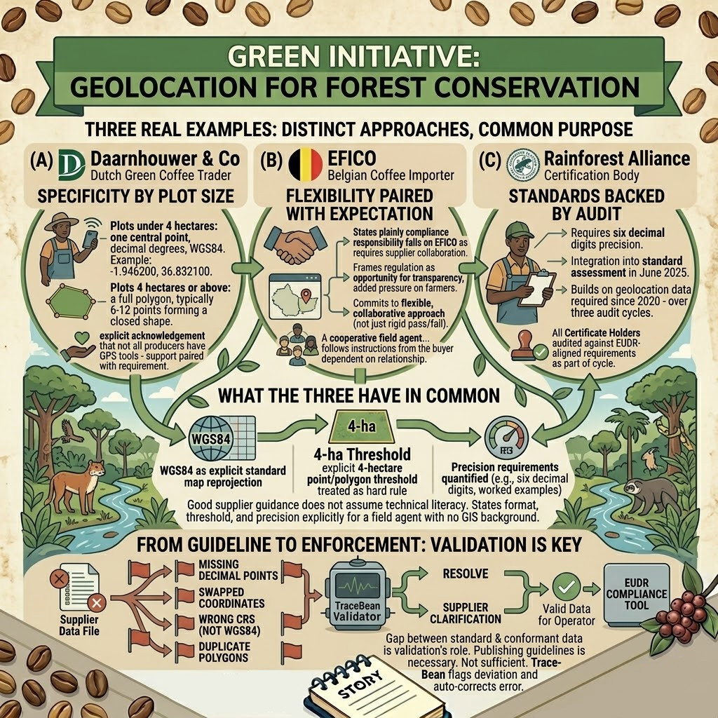
Daarnhouwer — specificity by plot size
Daarnhouwer & Co
Green coffee & cocoa trader, Netherlands- Plots under 4 hectares: one central point, latitude and longitude in decimal degrees, WGS84 format. Example given explicitly: -1.946200, 36.832100.
- Plots 4 hectares or above: a full polygon, typically 6–12 points forming a closed shape.
- Explicit acknowledgement that not all producers have GPS tools — guidance is paired with support, not just a requirement.
What makes Daarnhouwer's guidance effective is its specificity. It does not say "provide accurate coordinates." It says exactly which format, exactly which threshold, and gives a worked example with real-looking numbers. A field agent reading this document knows precisely what a compliant record looks like before they collect a single point.
The explicit point-vs-polygon threshold at 4 hectares — stated as a clear rule rather than left implicit — removes the single most common source of confusion we see in supplier files. When a guideline states the threshold this plainly, suppliers who read it have no excuse for submitting a point geometry on an 8-hectare plot. The ones who still do are the ones who never read the guideline, or whose field collection process has no mechanism for checking plot size before choosing geometry type.
EFICO — flexibility paired with expectation
EFICO
Green coffee importer, Belgium- States plainly that compliance responsibility falls on EFICO as the operator — but achieving it requires supplier collaboration.
- Frames the regulation as an opportunity to increase supply chain transparency, while explicitly recognising the added pressure on farmers.
- Commits to a flexible, collaborative approach rather than a rigid pass/fail requirement.
EFICO's published guidance leads with relationship framing before it gets to technical specification. This is a deliberate choice — and a reasonable one. A supplier who feels that geo-data requirements are an imposition from a distant regulator is less motivated to comply carefully than one who understands their buyer is trying to make the transition manageable.
This matters because most of the actual data — the coordinates, the polygons — is collected by people several steps removed from the importer who needs it. A cooperative field agent in a remote growing region will never read an EU regulation. They will, however, follow instructions from the buyer their cooperative depends on, if those instructions are communicated as part of an ongoing relationship rather than a compliance ultimatum.
Rainforest Alliance — standards backed by audit
Rainforest Alliance
Certification body- Requires six decimal digits of coordinate precision — moved from self-selected to integrated assessment in June 2025.
- All current and future coffee and cocoa Certificate Holders are audited against EUDR-aligned requirements as part of the standard certification cycle.
- Builds on geolocation data collection already required over three prior audit cycles since 2020 — this was not a sudden new demand.
What distinguishes the Rainforest Alliance's approach is enforcement. A guideline that specifies six decimal digits of precision is only as good as the mechanism that checks for it. By integrating the requirement into the standard audit cycle — rather than leaving it as a recommendation — non-compliance has a consequence: certification risk.
This is the piece that a trader's supplier guidelines, however well written, cannot easily replicate. Daarnhouwer and EFICO can ask their suppliers to follow specific technical requirements. Neither has the structural leverage of a certification body whose seal of approval suppliers depend on for market access across multiple buyers, not just one.
What the three have in common
Despite different organisational positions — trader, importer, certifier — all three guidelines converge on the same core technical requirements.
- WGS84 is the explicit standard. None of the three guidelines leave coordinate system ambiguous. All specify WGS84 directly, removing the most common source of silent coordinate errors before data collection even begins.
- The 4-hectare point/polygon threshold is stated explicitly. Every guideline treats this as a hard rule, not a judgment call left to the field agent.
- Precision requirements are quantified. Six decimal digits, decimal degree format, worked examples — none of the guidance is left as a vague instruction to "be accurate."
The pattern across all three: good supplier guidance does not assume technical literacy. It states the format, the threshold, and the precision explicitly enough that a field agent with no GIS background can follow it correctly on the first attempt.
What a guideline cannot do
Publishing clear requirements is necessary. It is not sufficient. None of the three organisations' guidelines — however well written — can guarantee that the geo-data arriving from hundreds of smallholder farmers, across multiple cooperatives, collected over multiple seasons with multiple tools, actually conforms to the standard that was published.
A guideline is read once, by someone, at some point. The data that eventually arrives reflects whatever that person remembered, whatever tool they had access to, and whatever shortcuts seemed reasonable under time pressure. The gap between "we told suppliers to use WGS84" and "every coordinate in this file is actually WGS84" is exactly the gap that validation exists to close.
This is true even for Rainforest Alliance-certified supply chains, where the audit cycle provides a stronger enforcement mechanism than a trader's guidance document. An audit happens periodically. A shipment happens continuously. The geo-data for this month's shipment needs to be correct now, not at the next audit cycle.
From guideline to enforcement
The organisations that benefit most from publishing clear supplier guidelines are the ones that pair the guideline with a process that checks compliance against it — automatically, on every file, before submission.
A guideline that says "polygons must be 6–12 points forming a closed shape" is operationalised when a validation step actually counts the points, checks ring closure, and flags any polygon that does not meet the stated standard — with the specific deviation named, not just a generic rejection.
A guideline that says "WGS84 format required" is operationalised when every incoming file is checked against the declared coordinate system, and reprojected automatically when it is not WGS84 — rather than discovering the mismatch when farms appear in the wrong country.
The technical requirements published by Daarnhouwer, EFICO, and the Rainforest Alliance — WGS84 format, the 4-hectare threshold, six-decimal precision, closed polygon rings — map directly onto checks TraceBean already runs on every file processed. The guideline defines the standard. Validation confirms the standard was actually met.
For importers who have not yet published their own supplier requirements, these three examples are a reasonable starting point — adapted to specific commodities, origins, and supplier relationships as needed.
Sources: Daarnhouwer & Co, EUDR Geolocation Data Guide; EFICO Supplier Requirements for EUDR Compliance; Rainforest Alliance, EUDR Alignment Policy.
← Back to Blog