Ask most people where deforestation happens in Brazil, and they will say the Amazon. They are not wrong. But they are missing half the story.
South of the Amazon basin lies the Cerrado — a tropical savanna covering roughly 20% of Brazil's land area, the most biodiverse savanna on Earth, and for the past two decades, the single largest source of new agricultural land in the country. Soybeans, in particular, have expanded into the Cerrado at a scale that dwarfs soy expansion into the Amazon itself.
Here is the question worth sitting with: if your deforestation check relies on a global satellite dataset built to detect dense canopy loss, is it possible that it sees the Cerrado's transformation differently than it sees the Amazon's — or barely sees it at all?
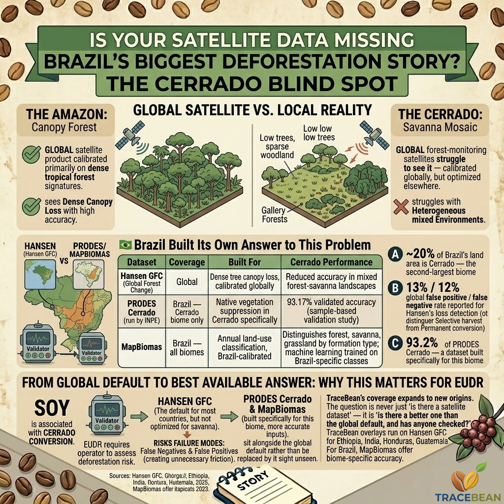
A savanna is not an empty rainforest
The Cerrado is not bare grassland. It is a complex mosaic of grassland, shrubland, and woodland — ranging from open fields with scattered low trees to dense gallery forests along waterways. Tree cover within the Cerrado varies enormously across this gradient, often sitting well below the canopy density that global forest-monitoring tools were designed to detect.
This matters because the most widely used global deforestation dataset — Hansen Global Forest Change, the satellite product behind Global Forest Watch and a common reference layer in EUDR compliance tools — measures tree cover and tree cover loss. It does not measure land use, and it does not distinguish between biomes. A hectare of dense canopy loss in the Amazon and a hectare of sparse woodland conversion in the Cerrado are processed through the same algorithm, calibrated primarily on dense tropical forest signatures.
The Hansen dataset's own documentation describes "loss" as a purely biophysical event — a disturbance leading to reduced tree cover. It does not distinguish forest from savanna, or selective harvest from permanent conversion. That is a reasonable design choice for a global product. It is also exactly why it struggles with landscapes that were never dense forest to begin with.
What this looks like in practice
Independent accuracy assessments comparing satellite vegetation products against ground-based laser scanning in heterogeneous forest-savanna landscapes found that Hansen's tree cover product was measurably less accurate than other global datasets in exactly these mixed environments — the kind that define large parts of the Cerrado.
The same research that flagged Hansen's limitations in mixed landscapes noted something equally important: a globally consistent dataset is valuable precisely because it is consistent everywhere. The trade-off is that "everywhere" includes landscapes the underlying model was never optimised for. Brazil's own land-monitoring agencies reached the same conclusion years ago — which is why two homegrown alternatives exist specifically to address it.
Brazil built its own answer to this problem
This is the part of the story that rarely makes it outside Brazil. The gap between global tools and Cerrado reality was significant enough that Brazilian institutions built dedicated monitoring systems rather than relying solely on global products.
PRODES Cerrado, run by Brazil's national space research institute (INPE), has produced annual deforestation monitoring specifically for the Cerrado biome since 2016 — extending a methodology that had monitored the Legal Amazon since 1988. Independent sample-based validation found PRODES Cerrado achieved 93.17% overall accuracy, calibrated specifically to distinguish native Cerrado vegetation loss from the biome's natural heterogeneity.
MapBiomas takes a complementary approach — annual land-use and land-cover classification across all of Brazil since 1985, using machine learning trained on Brazil-specific vegetation classes at the formation level: forest, savanna, grassland, and dozens of other categories. Where Hansen answers "did tree cover decrease here," MapBiomas answers "what was here before, and what is here now" — the land-use context that a biophysical tree-cover signal alone cannot provide.
| Dataset | Coverage | Built for | Cerrado performance |
|---|---|---|---|
| Hansen GFC | Global | Dense tree canopy loss, calibrated globally | Reduced accuracy in mixed forest-savanna landscapes |
| PRODES Cerrado | Brazil — Cerrado biome only | Native vegetation suppression in Cerrado specifically | 93.17% validated accuracy |
| MapBiomas | Brazil — all biomes | Annual land-use classification, Brazil-calibrated | Distinguishes forest, savanna, grassland by formation type |
Both PRODES Cerrado and MapBiomas are public, open, and free to use — published under open licences, with API access available through Brazil's TerraBrasilis platform and Google Earth Engine respectively. This is not a case of better data existing behind a paywall. It exists, it is free, and it was built for exactly this problem.
Why this stays invisible outside Brazil
Hansen GFC is the default reference layer in most global compliance and deforestation-risk tools, for a straightforward reason: it covers the entire planet in a single, consistent format. A compliance tool serving importers across Ethiopia, Indonesia, Honduras, and Brazil needs one dataset that works everywhere, not forty country-specific ones.
That consistency is genuinely valuable. It is also the reason a country-specific blind spot like the Cerrado can persist inside a global system without anyone noticing — the tool is doing exactly what it was built to do. It is simply not the most accurate tool available for this particular landscape.
A global default is not the same as the best available answer. For most geographies, it is the only practical answer. For a handful of countries that have invested in their own monitoring infrastructure, it is a reasonable second opinion at best.
Why this matters for EUDR specifically
EUDR requires operators to assess deforestation risk for every relevant commodity, including soy — and soy is the commodity most closely associated with Cerrado conversion. A deforestation risk assessment built entirely on a global dataset that under-detects change in savanna landscapes risks two failure modes at once: false negatives that miss genuine conversion, and false positives that flag legitimate agricultural land as risky because its baseline vegetation never looked like dense forest to begin with.
Neither failure mode serves the regulation's purpose. The first lets non-compliant sourcing through. The second creates unnecessary friction for farms that were never the problem.
For commodities and geographies where a national monitoring system exists — built, validated, and maintained by the country's own institutions — that system is not a curiosity. It is the more accurate input, and it deserves to sit alongside the global default rather than be replaced by it sight unseen.
The broader pattern worth remembering
The Cerrado is the clearest example we have found of this pattern, but it is unlikely to be the only one. Any global satellite product calibrated primarily on dense tropical forest will carry some version of the same limitation wherever the local landscape does not match that calibration — dry forests, mangroves, degraded secondary growth, and other vegetation types that do not photograph the way a rainforest does.
The practical takeaway is not "distrust global datasets." It is narrower and more useful than that: before treating a single global dataset as the final word on deforestation risk for a given geography, it is worth checking whether the country in question has built something more precise for itself — and, if so, why that resource is not already part of the conversation.
TraceBean's deforestation overlay currently runs on Hansen GFC tiles for Ethiopia, India, Honduras, and Guatemala — geographies where a global dataset is the most practical available option. Brazil is a different case, with PRODES Cerrado and MapBiomas offering biome-specific accuracy that a global default cannot match. As TraceBean's coverage expands to new origins, the question is never just "is there a satellite dataset for this country" — it is "is there a better one than the global default, and has anyone checked?"
Sources: Hansen et al., Global Forest Change methodology documentation; comparative accuracy studies of MODIS VCF, Hansen GFC, and Global Forest Canopy Height Model in forest-savanna mosaics; PRODES Cerrado validation study (ScienceDirect); MapBiomas and TerraBrasilis open data platforms.
← Back to Blog