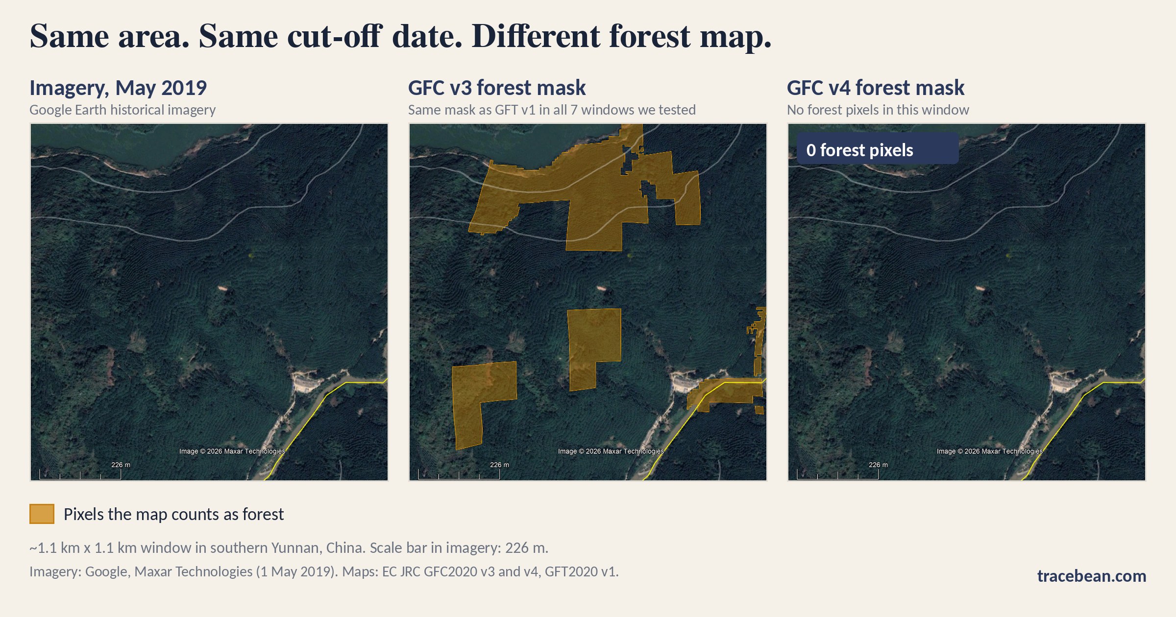
An EUDR operator who checks a polygon against a forest map for 31 December 2020 usually writes down the answer. Fewer write down which version of the map gave it. We compared three of the Commission's own forest layers pixel by pixel and found that the version can change the answer for the same piece of land, in a way the date alone does not predict.
What we compared
The JRC publishes two maps for the 2020 cut-off. The global forest cover map (GFC2020) says whether a pixel was forest. The global forest types map (GFT2020) divides forest into primary, naturally regenerating and planted forest. The Commission's FAQ (version 5, April 2026) points readers to version 3 of the forest cover map, dated December 2025, "with an overall increased accuracy of above 92%". A newer version, 4, is now the one listed as current in the Earth Engine catalog, which marks version 3 as superseded.
We loaded GFC2020 versions 3 and 4 and GFT2020 version 1 into one database and compared them over seven windows of about 1 km by 1 km (14,400 pixels each, 100,800 in total) in southern Yunnan, China. Five windows sit at the edge of plantations. Two sit inside continuous forest as a control. For two windows we then looked at the forest patches against historical Google Earth imagery from 2019 and 2020.
This is a sample, not a survey. We picked the windows ourselves, most of them at plantation edges, so the percentages below describe these windows and nothing larger.
Finding 1: the type map sits on version 3
In all 100,800 pixels, the forest mask of GFT2020 version 1 is identical to the forest mask of GFC2020 version 3. There is not a single pixel where one says forest and the other says not. The JRC pages we read do not state which version the type map is built on. The pixels do.
Finding 2: version 4 removed most of the planted class
In the five windows near plantations, version 4 shows about half as much forest as version 3 (7,675 pixels against 15,120). In the two control windows in continuous forest, all three layers are identical. The change is concentrated where plantations are.
| Class in version 3 / GFT | Pixels | Still forest in v4 | Not forest in v4 |
|---|---|---|---|
| Planted / plantation forest (20) | 5,570 | 64 (1%) | 5,506 (99%) |
| Naturally regenerating forest (1) | 9,550 | 6,439 (67%) | 3,111 (33%) |
One pixel is roughly 80 m², so the 5,506 planted-class pixels that version 4 no longer counts as forest cover about 44 hectares. Version 4 also added forest in two windows where version 3 had none (1,172 pixels). We have not checked those against imagery, so we make no claim about whether that is right.
What the imagery shows
In the first window we checked, imagery from May 2019 shows plantation in every version 3 forest polygon except the ones in the lower right. Those lower-right polygons include a river, and we did not settle whether the rest of them was natural forest. Version 4 shows no forest at all in this window, so it removed the plantation polygons and the lower-right ones alike. In the second window, imagery from 2020 shows dense terraced plantation with terraces visible in earlier years, a bare terraced patch, and a mixed area with some natural vegetation between plantation blocks. Version 4 removed most of the first kind of polygon, which is what the imagery supports. It also removed the second kind, which the imagery does not clearly support.
One 2-hectare patch in the second window we could not settle. On the 2020 imagery most of it looks like plantation, but not clearly, and today it shows a closed, unterraced canopy. A mature plantation can close its canopy and hide its terraces, so the present-day look does not tell us what it was in 2020. We could not decide it from imagery, and we do not claim to have.
A smaller observation: several version 3 forest polygons have straight sides and right angles, next to edges that follow single pixels. That suggests an input with coarser resolution. The JRC names the 100 m Global Forest Management Map among the inputs for its forest cover work. We have not tested whether that explains the blocks, so we treat it as a question.
What we cannot say
- That version 4 is right everywhere. We checked two windows against imagery. In both it removed plantation, but it also removed areas that may have been natural forest (lower right of the first window, the hilltop patch in the second).
- Why version 4 changed what it did. The JRC lists its technical report for version 4 as expected by December 2026. Until it appears, the reasons are not documented in the sources we read.
- That the removed pixels are rubber. We saw terraced plantation. We did not identify the crop.
What this means for a due diligence file
The Commission calls both maps non-binding and says the type map is "not intended as definitive source of information for compliance". Operators are free to use them, and many will. The point is that a result is only as repeatable as the version behind it. A check run on version 3 in spring and the same polygon re-run on version 4 in autumn can give different answers, with nothing wrong in the polygon.
- Record the map, its version and the date you queried it, next to the result.
- Keep the earlier result when you re-run. Overwriting it removes the evidence of what you knew at the time.
- Treat a change between versions as a prompt to look, not as a verdict in either direction. As we wrote about rubber, the planting year per plot is what settles whether land was forest or plantation, and no map substitutes for it.
TraceBean does not decide what a forest map should have said. We check that the polygon a map is run against is correct: valid geometry, coordinates inside the stated country, no duplicates or overlaps, consistent formats and coordinate systems.
A new map version changes the answer for the same polygon. A wrong polygon changes the question.
Method: pixel comparison of GFC2020 v3, GFC2020 v4 and GFT2020 v1 in PostGIS over seven windows of about 1 km × 1 km in southern Yunnan, China, with a visual check of two windows against Google Earth historical imagery (May 2019 and 2020). Sources: Commission FAQ on the implementation of the EUDR, version 5 (April 2026), section 9.10; EC JRC global map of forest cover 2020, V3 and V4 (Earth Engine catalog); EC JRC global map of forest types 2020, V1; JRC Global Forest Cover 2020; Bourgoin et al., Global map of forest cover 2020 (ESSD discussion), for the forest management input.
← Back to Blog