Some regulations generate years of anticipation, then land with a quiet thud. EUDR is not one of those. It has generated years of anticipation, two legislative delays, four rounds of revised guidance, and now — with Version 5 of the FAQ published in April 2026 — a clear signal from the European Commission: this is the final version. The basic legal text is not changing. The deadline is not moving.
For green coffee importers who have been watching and waiting, that signal matters. The window for preparation is now measurable in months, not cycles.
This is not a comprehensive summary of 95 pages of Commission guidance. It is a focused read of what is new, what is clarified, and what has direct implications for the farm-level geo-data that sits at the foundation of every Due Diligence Statement.
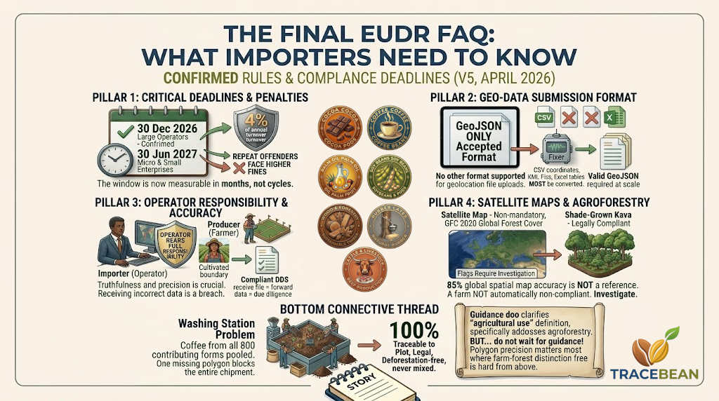
The deadline is final. Waiting is no longer a strategy.
The Commission's April 2026 review concluded that measures introduced between 2024 and 2025, together with December 2025 amendments, deliver sufficient simplification. Its conclusion is direct: further amendments to the basic legal text are not appropriate.
This closes the door on the pattern of the past two years, where each approaching deadline was accompanied by expectations of further delay or revision. Two delays have already been granted. A third is not coming.
For importers who have deferred supplier engagement on geo-data grounds — waiting for the rules to stabilise before asking suppliers for polygons — that deferral is now a cost. The rules are stable. The deadline is seven months away.
GeoJSON is the only accepted format. Not CSV. Not KML. Not Excel.
The FAQ confirms what was announced in April 2024: GeoJSON is the only format accepted for uploading geolocation data as a file to the EUDR Information System. The Commission's reasoning is explicit — GeoJSON is the only non-proprietary format that supports the coordinate system requirements and allows submission of the additional properties needed.
If a supplier delivers farm geo-data in any other format — CSV coordinates, KML files, Excel tables, shapefile exports — that data must be converted to valid GeoJSON before it can be submitted to the Information System. That conversion is not trivial at scale.
This is relevant for importers who receive geo-data from suppliers in whatever format the supplier happens to use. The supplier's obligation is to provide the data. The operator's obligation is to ensure it is correct and submittable. Those are two different things — and the gap between them is exactly where data quality problems accumulate.
The operator bears full responsibility for geo-data accuracy — regardless of source.
FAQ 1.11 and 1.12 are unambiguous on this point. An operator may use geo-data provided by a producer. But it is the operator — not the producer — who is ultimately responsible for its accuracy.
The FAQ goes further: ensuring the truthfulness and precision of geolocation information is a crucial aspect of the responsibilities that operators must fulfil. Providing incorrect information constitutes a breach of the operator's obligations under the Regulation.
This applies whether the inaccuracy is a swapped coordinate, a point geometry submitted where a polygon is required, a polygon that extends beyond the cultivated plot boundary, or coordinates that place a farm on the wrong continent. The operator submitted the DDS. The operator is responsible.
This is the structural reason why receiving a geo-data file from a supplier and submitting it to a compliance tool without validation is not a due diligence process. It is a data forwarding process — and it transfers none of the legal responsibility.
The satellite map is not legally binding. But ignoring it is not safe either.
FAQ 9.10 makes an important clarification that is often misunderstood in both directions. The EU Observatory's Global Forest Cover map for 2020 is described as non-mandatory, non-exclusive, and non-legally binding.
Non-mandatory means operators are not obliged to use it. Non-exclusive means operators may use other, more granular maps. Non-legally binding means that a farm located within a forest-classified area on the map is not automatically non-compliant.
What the FAQ does not say is that operators can ignore the map. It says the map is a risk assessment tool — one of many — and that a flag on the map triggers an obligation to investigate further, not a pass to submit without additional evidence.
The FAQ also confirms something directly relevant to the agroforestry misclassification problem we covered in the previous post: the overall accuracy of global spatial maps is around 85%, with national maps reaching 90%. Neither can be considered a reference map for due diligence or verification at local scale. The Commission is aware that these maps have errors. The implication — made explicit in FAQ 9.10.3 — is that a farm on land designated as forest in the GFC 2020 map is not automatically non-compliant. It is a flag that requires further investigation.
Agroforestry guidance is coming. Officially.
FAQ 9.7 contains a sentence that directly validates the concern we raised in the previous post. The Commission confirms it has published a Guidance document as a Commission Notice to elaborate on the definition of "agricultural use" — and that this document will specifically address issues related to agroforestry and agricultural land.
This is significant for two reasons. First, it confirms that the Commission acknowledges agroforestry as an area requiring clarification — the current rules are ambiguous enough that official guidance was deemed necessary. Second, it means importers sourcing from shade-grown or agroforestry systems cannot wait for that guidance to land before beginning geo-data validation. The guidance will clarify the rules. It will not validate incomplete or imprecise geo-data retroactively.
The guidance on agroforestry is coming. The December 2026 deadline is not waiting for it.
One missing polygon can still block an entire shipment.
FAQ 1.5 is the clearest statement in the document on what happens when part of a batch is non-compliant. If non-compliant products cannot be identified and separated from the rest — for instance because bulk commodities have been mixed and are linked to several hundred plots of land — the fact that one of the plots of land was deforested after 2020 makes the whole relevant batch non-compliant.
This is the washing station problem in the language of the regulation itself. Coffee pooled at a processing facility cannot be retroactively separated by farm. If the geo-data for any contributing farm is non-compliant, the DDS for the entire batch is compromised.
The regulation provides one path to compliance: 100% of relevant commodities must be traceable to a plot of land, legal, deforestation-free, and never mixed with commodities of unknown origin. There is no partial compliance option.
What this means in practice for importers in the next seven months
The FAQ is a clarification document, not an action plan. But read through the lens of what it confirms, the priorities for a green coffee importer between now and December 2026 are relatively clear.
- Request geo-data from all suppliers now. Not as shipping documentation. As a standalone dataset to be validated before the harvest season. The FAQ confirms the operator bears full responsibility for accuracy. That responsibility cannot be met by receiving a file with the cargo documents.
- Validate that geo-data before it reaches a compliance tool. The Information System accepts GeoJSON only. A file in any other format, or with coordinates outside the expected country boundary, or with point geometries for plots above 4 hectares, will not result in a compliant DDS.
- Address agroforestry farms with extra care. The satellite map is not definitive. A flag is not a rejection. But an imprecise polygon on an agroforestry farm — one that extends into adjacent forest — will increase the apparent overlap and raise the risk score. Polygon precision matters most where the distinction between farm and forest is hardest to see from above.
- Do not wait for further guidance. The Commission is issuing guidance on agroforestry. It will not rewrite the deadline, and it will not validate geo-data that was never collected or validated.
TraceBean validates farm geo-data files before they reach a compliance tool — checking geometry type, coordinate accuracy, country boundary consistency, and GeoJSON format compliance. Every record that fails validation gets a farm-level flag and an actionable correction message. The goal is to surface problems in weeks, not hours before a DDS submission deadline.
Source: European Commission, Frequently Asked Questions — Implementation of the EU Deforestation Regulation, Version 5, April 2026.
← Back to Blog