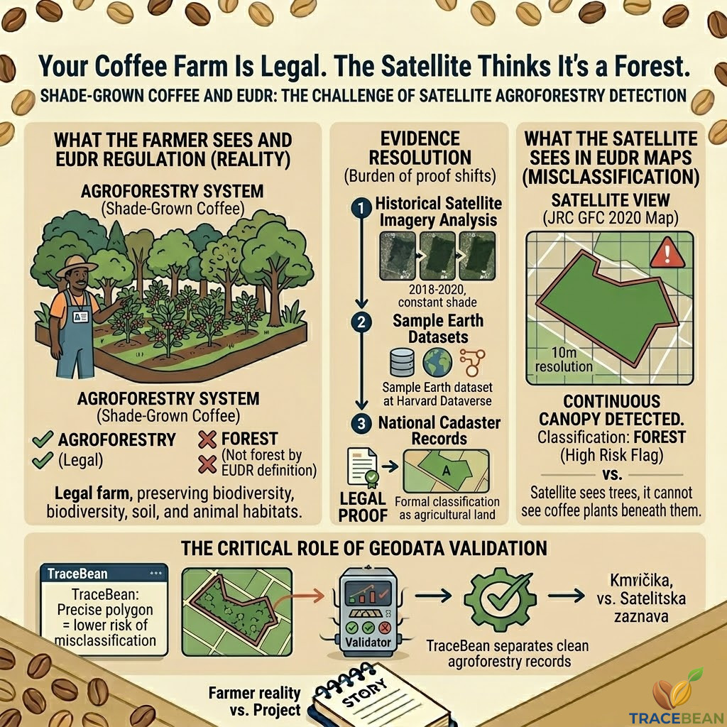
Shade-grown coffee is, by almost every measure, a good thing. It preserves biodiversity, supports soil health, provides habitat for migratory birds, and produces coffee that often commands a premium price. Farmers who grow coffee under a canopy of trees are not deforesting — they are farming.
EUDR knows this. The regulation explicitly excludes agroforestry from its definition of forest. A coffee farm under shade trees, cultivated before December 2020, is legally compliant by design.
The satellite maps used to enforce that compliance do not always agree.
What the regulation actually says
EUDR Article 2(6) defines an agricultural plantation as land where tree stands are part of an agricultural production system — explicitly including agroforestry systems where crops are grown under tree cover. Agricultural plantations are not classified as forests under the regulation.
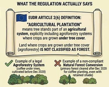
This means that a coffee or cocoa farm grown in the shade of native or planted trees is, in the language of the regulation, agricultural land. Growing coffee under a canopy does not constitute deforestation. Managing those shade trees — pruning, thinning, replacing — does not constitute deforestation.
What does constitute deforestation under EUDR is converting natural forest into agroforestry after 31 December 2020. If a farmer cleared primary forest and planted coffee there — even under retained shade trees — that land is deforested in the regulatory sense, and the coffee produced there cannot legally enter the EU market.
Coffee grown under shade trees on land that was agricultural before December 2020 — regardless of how forest-like it looks from above.
Coffee planted on land that was natural forest after December 2020, even if native shade trees were retained rather than cleared.
The distinction is clear in the text of the regulation. It is much less clear from a satellite.
What a satellite actually sees
Satellite-based forest monitoring works by detecting tree cover — specifically, canopy density above a defined threshold. The EU's reference forest map (the JRC Global Forest Cover 2020 map, used as the baseline for EUDR deforestation assessments) classifies land as forest based on tree cover percentage, height, and area.
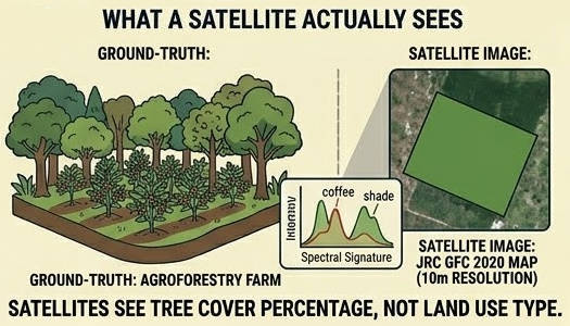
A mature shade-grown coffee garden — with a dense canopy of Erythrina, Grevillea, or native forest trees above the coffee plants — can register the same spectral signature as a tropical forest. From 10 metres resolution, the satellite cannot see the coffee plants beneath the canopy. It sees trees. It classifies the land as forest.
This is not a flaw in the satellite technology. It is a fundamental limitation of what remote sensing can observe. Tree cover is visible from space. Whether those trees are part of a forest or an agricultural system is not.
The scale of the problem
This is not a theoretical edge case. Researchers at Wageningen University published findings in July 2025 that quantify the misclassification rate for agroforestry in EUDR-relevant geographies.
Source: van Noordwijk et al., People and Nature, July 2025
A separate study examining coffee-growing regions in Ethiopia and Tanzania found high rates of misclassification specifically for shade-grown and agroforestry cultivation — the farming systems that are, by any reasonable environmental standard, the most sustainable way to grow coffee.
The practical implication: a compliant farm can trigger a high-risk flag in a compliance tool not because of anything the farmer did wrong, but because the satellite map cannot distinguish what is growing beneath the canopy.
What happens when an agroforestry farm flags as high-risk
When a satellite-based compliance tool identifies a farm polygon as overlapping with forest cover in the 2020 baseline map, it generates a deforestation risk flag. For the importer, this means the farm cannot be included in a Due Diligence Statement without additional evidence that the land was not deforested.
For a sun-grown plantation on cleared land, this is usually straightforward to resolve — the land parcel looks nothing like forest, and the satellite agrees.
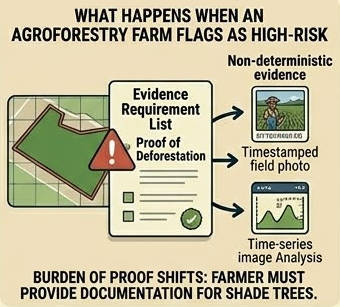
For a shade-grown agroforestry farm, the satellite flag may be correct in what it observed — tree cover — and completely wrong in what it implies. The farm is not deforested. It has always been agricultural land. But the evidence required to prove this to a compliance tool is significantly more complex than a polygon and an area figure.
EFICO — one of Europe's larger green coffee importers and a company that has published detailed EUDR supplier guidelines — explicitly acknowledges this in their documentation. When automated risk assessment identifies high-risk plots and detailed analysis cannot resolve the flag, suppliers must submit additional documentation including identification of causes of any apparent deforestation and details on specific activities such as intensive pruning in agroforestry systems.
In other words: the burden of proof shifts from the compliance system to the farmer. A farmer growing coffee the same way their grandparents did, under the same trees, must now produce documentation to prove that those trees do not make their farm a forest.
What evidence can resolve an agroforestry flag
The research community and the policy community are converging on the same answer: satellite data alone is not sufficient to adjudicate agroforestry cases. Additional evidence is required.
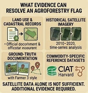
- Land use and cadastral records. National land registries that classify a parcel as agricultural land pre-2020 carry significant evidentiary weight. The challenge: in many origin countries, smallholder agroforestry plots are not formally registered, or the registry uses classifications that do not map cleanly onto EUDR categories.
- Historical satellite imagery. Time-series analysis showing continuous agricultural land use — coffee plants visible in imagery from 2018, 2019, 2020 — can demonstrate that the canopy has been present as agroforestry, not as natural forest, for years. This requires access to historical data and specialist analysis.
- Ground-truth documentation. Field photographs, GPS-timestamped records of farming activity, cooperative membership records showing the farmer has delivered coffee from the same plot for years. Strong contextual evidence, but difficult to standardise at scale across thousands of smallholder farms.
- Commodity-specific reference datasets. In November 2025, the Alliance of Bioversity International and CIAT launched Sample Earth — a reference dataset designed specifically to help compliance mappers stop misclassifying smallholder coffee and cocoa farms as forest. The dataset is hosted at Harvard Dataverse and is openly accessible. Its adoption by compliance tools is still in progress.
The European Commission is expected to issue additional guidance on the definition of "agricultural use" — which will directly address agroforestry. Until that guidance arrives, importers and their suppliers are navigating a genuine regulatory grey area.
What this means for geo-data quality
This is where the agroforestry problem intersects directly with farm geo-data — and why it belongs in a series about upstream data validation.
The precision of a farm polygon matters more for agroforestry farms than for any other farm type. A polygon that is slightly too large — encompassing a tree line or a fragment of natural forest adjacent to the coffee plot — will increase the apparent tree cover overlap and raise the risk score. A polygon that correctly delineates only the cultivated area gives the compliance tool the best possible chance of distinguishing agroforestry from forest.
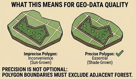
EFICO's supplier guidelines are explicit on this point: a coffee plot polygon should cover only the coffee plantations of a farm — whether sun-grown or shaded — and must exclude standing forest and other agricultural commodities, even if they are adjacent or interspersed.
For a sun-grown farm on cleared land, an imprecise polygon is an inconvenience. For a shade-grown agroforestry farm on land that looks like forest from above, an imprecise polygon can be the difference between a clean compliance check and a high-risk flag that requires months of additional documentation to resolve.
The structural problem EUDR has not yet resolved
The agroforestry misclassification problem is not a data quality problem in the conventional sense. The farms are real. The farming system is legitimate. The regulation explicitly permits it. The gap is between what the regulation says and what the enforcement mechanism can currently verify.
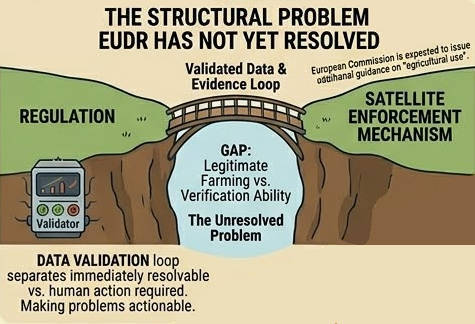
Researchers have called for the EUDR guidelines to be amended so that satellite data does not automatically prevail over national land registries — that the section stating satellite information should "prevail over" land registries be replaced with clearer reference to existing land use accounting methods already used under the UN Framework Convention on Climate Change.
Whether that change comes, and when, is a policy question. What importers and their suppliers can do now is ensure that the geo-data they submit gives every farm the best possible representation — precise polygons, accurate area figures, and where relevant, supplementary documentation that establishes the agricultural history of the land.
A farm that has grown coffee under shade trees for thirty years should not fail a EUDR check. The regulation agrees. Making the compliance system agree requires getting the data right.
TraceBean validates farm polygons for geometric correctness, coordinate accuracy, and area consistency — the foundations that every downstream compliance check depends on. For agroforestry farms specifically, polygon precision is not optional: the difference between a correctly drawn plot boundary and a loosely drawn one can determine whether a legitimate farm triggers a high-risk flag that takes months to resolve.